
ISO/TS 21219-19 - Intelligent transport systems – Traffic and Travel Information (TTI) via Transport Protocol Expert Group, Generation 2 (TPEG2) – Part 19:Weather Information (TPEG2-WEA)
Application Area: Traffic and Travel Information
Publication Year, Number of Pages: Published 2016, 82 pages
Extract Creation Year: 2022
Standard Topic Group: TPEG2
Standard Topic: informace o počasí
Topic Description: TPEG2, definice aplikace pro informace o počasí.
popis aplikace; UML diagramy příkladů zpráv, vizualizace zpráv
koncept TPEG zpráv; popis částí zprávy
pravidla pro sestavování zpráv; hierarchické vrstvení zpráv
UML definice zprávy o počasí
definice struktury kontejneru aplikace; definice elementů aplikace; definice binární struktury zprávy; xml schéma zprávy
číselníky frází; mapování frází do WMO SYNOP
Introduction
The ISO 21219 Technical Specification specifies the TPEG format and protocol for the provision of transport information to end users. TPEG is designed for high bandwidth media, allowing information to be structured with increasing levels of detail and complex location descriptions.
The different traffic event domains are described separately in TPEG, using a platform-independent model (UML) and two derived platform-dependent models (binary and XML). Parts of the specification set out the rules for the creation of the model and its conversion into a platform-dependent form.
More information on the context of TPEG is contained in the introduction to the extract for Part 1 of the TPEG standard (21219-1).
The ISO 21219 technical specification deals with the second generation of the TPEG protocol, abbreviated as TPEG2. The TPEG/TPEG1/TPEG2 distinction is usually only mentioned in the introductory part of the standards/specifications, while other chapters no longer distinguish between TPEG and TPEG2 - this is implicit by context.
This extract (hereafter referred to as the 'document under description') describes Part 19 of the TPEG standard 'Weather Information Application (TPEG2-WEA)', which describes the encoding of weather reports of various sizes.
Note: The extract lists selected chapters of the document described and adopts the original chapter numbering.
Application
The document described sets out how weather information is to be provided. It provides for the presentation of this information to the user. It contains a significant number of enumerations (tables) specifying weather types and also a converter between these tables and WMO SYNOP codes. It is essential for the analysts of the weather service operator and for the analysts of the user terminal (application) manufacturer who are responsible for the design of the system data model and the design of the rules with which the system operates. It shall be used in the design of the system.
1. Scope
The described document defines the TPEG WEA application "Weather Information Application". It allows the provision of weather information for different geographical areas (even hierarchically linked) at different time scales. The weather information can be very detailed. This information is intended for travellers in general and is not limited by the mode of transport, nor is it intended to provide warnings about dangerous weather conditions to drivers, for which another TPEG application (TPEG-TEC, 21219-15) is intended.
2. Related Documents (Selection)
The document described herein provides 3 normative references to TPEG2 ISO 21219 parts 5, 6 and 9. In addition, a number of normative references used in the text are referenced in the References section.
3. Terms and Definitions
This chapter defines 5 terms, including:
message management container; MMC (message management container) part of a message containing information for building a message from other "application" and "location" containers or for managing a message (for example, cancelling it).
location referencing container; LRC (location referencing container) part of a message containing information about the location of the referenced traffic information or referenced traffic state.
location referencing - a means of enabling the system to accurately identify a location
4. Abbreviations
This chapter sets out 16 abbreviations, the important ones in terms of this extract are:
MMContainer for message management (Message Management Container)
ADContainer for application description (Application Data Container)
LRContainer for Location Referencing Container
WEA Weather information application (Weather information application)
TPEGframework providing formats and protocols for the provision of traffic information, optimised for dissemination via digital radio or the Internet
Note: Additional ITS terms and abbreviations can be found in the Glossary of ITS Terminology (www.itsterminology.org).
5 Conditions and limitations of the application
This chapter (1.5 pages) defines:
- The application identifier that is specified for all applications in TS 21219-1.
- Application version. The version is crucial from the decoder's point of view, as different versions of the same application may differ in structure, content, etc.
- The order of the containers of which the message is composed. A message consists of a Message Management Container (MMC), and optionally an Application Description Container (ADC) and a Location Referencing Container (LRC).
- Extensibility and backward compatibility, such as the requirement to skip unknown parts of the message by the decoder and the specification of future extensible parts of TPEG message structures.
- TPEG service component framework according to ISO/TS 21219-5.
6 Structure of the WEA
This chapter (scope 1 UML schema) contains the UML model of the WEA application message.
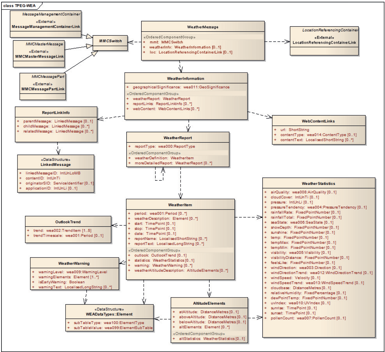
Figure 1 - UML class model of the WEA application (Figure 2 of the standard)
7 Components of the WEA report
This chapter (8 pages, tables, figures) describes the individual components of the WEA report. The aim is to introduce a hierarchical structure of interconnected reports with different forecast coverage or time horizons.
It sets out the basic structure of the WEA report and describes its individual components in detail. The basic message "WeatherMessage" may contain weather information (WeatherInformation) and location information (LocationReferencingContainerLink), not necessarily in one message.
The weather information consists of the type of the described area, the report itself (WeatherReport) and related reports referenced by the ID. Each weather report consists of a report type and item (WeatherItem) and a possible detail report. The item (WeatherItem) already contains specific weather information, including forecasts (OutlookTrend) detailed numerical statistics (WeatherStatistics), warnings about specific weather (WeatherWarning) and the altitude distribution of the weather (AltitudeElements).
The WeatherStatistics item (ch 7.5) covers 25 weather figures such as temperature, wind, dew point, sunrise, pressure, precipitation and more.
The description of the position is not specified.
8 WEA data types
This chapter (1 page) contains definitions of 2 data structures (types) used. Namely LinkedMessage allowing to hierarchically link messages to each other using messageID and Element qualitatively describing the weather type.
9 WEA tables
This chapter (20 pages in length) contains definitions of the WEA enumeration application types (in 29 tables). The following table lists each table by name and adds a description and example content.
Table 1 - List of WEA tables (source: author of extract)
WEA table | Description | Table of Contents |
wea000:ReportType | Report type (0-5) | Ex:002: Daily |
wea001:Period | Description of validity period (0-50) | Ref: 019: Dusk |
wea002:TrendItem | Weather trend (0-16) | Ex: 004: hotter |
wea003:Direction | Weather direction (0-16) | Ex: 013: W (west) |
wea004:PressureTendency | Pressure trend (0-6) | Re: 003: Falling |
wea005:Visibility | Visibility (0-4) | Ex: 002: Poor |
wea006:SeaState | Wave height at sea (0-7) | Ref: 003: Rough |
wea007:PollenCount | Amount of pollen particles (0-3) | Re: 002: High |
wea008:AirQuality | Weather quality (0-6) | Ex: 003: Unhealthy |
wea009:WarningLevel | weather threat level (0-4) | Ex: 002: Bad weather |
wea010:UVIndex | UV index (0-11) | Ex: 010: 10-very high |
wea011:GeoSignificance | Meaning / range (0-9) | Re: 006: City |
wea012:WindDirectionTrend | Wind direction trend (0-2) | Ex: 001: Veering |
wea013:WindSpeedTrend | Wind speed trend (0-4) | Ex: 003: Decreasing |
wea014:ContentType | Description of content type (0-6) | Ex: 004: Pressure |
wea099:ElementSubTable | Table of weather subtypes (0) | empty |
wea100:ElementType | Weather element table (0-12) | Ex: 006: wea106_FogElements |
wea101:RainElements | Rainy weather description (0-12) | Ex: 012: Damp |
wea102:SnowElements | Description of snow weather (0-14) | Ex: 006: Low drifting snow |
wea103:SleetHailElements | Bad weather description (0-11) | Ref: 002: Light sleet |
wea104:WindElements | Wind weather description (0-27) | Ref: 012: Hurricane |
wea105:StormElements | Stormy weather description (0-12) | Ref: 012: Sand storm |
wea106:FogElements | Description of foggy weather (0-13) | Re: 004: Shallow fog |
wea107:FrostElements | Ice weather description (0-5) | Ex: 004: Severe frost |
wea108:SunshineCloudElements | Description of solar cloud cover | Re: 005: A few clouds |
wea109:TemperatureElements | Temperature description (0-12) | Ex: 008: Heat-wave |
wea110:HazardElements | Threat Description (0-13) | Ex: 005: Landslides |
wea200:ElementQualifier | Environment description (0-25) | Ref: 003: Urban areas |
wea201:ElementQualifierProbability | Probability of realisation | Ex: 001: 10 % |
The following table contains an example of the "wea200:ElementQualifier" table from the document described.
Table 2 - Example of part of the definition of the enumeration type wea200:ElementQualifier (Table 41 of the standard)
Code | Phrases | Comment |
000 | In some areas | In the overall area referred to, the element may not be present everywhere, but only in some places |
001 | Low lying areas | Elements such as fog may be more common in valleys and low-lying areas near rivers. |
002 | High ground | Elements such as frost and snow may be more likely in high areas. |
003 | Urban areas | Urban areas have their own microclimates, so sometimes they are warmer or smog can be a problem. |
Annex A (normative) TPEG-bin representation of WEA
This annex (9 pages) specifies the binary representation of the WEA application for use in DAB. A pseudocode is used to describe the binary representation, where for each keyword of the written structure its binary form is known.
The annex contains separately listed binary representations of the TPEG framework, the WEA message and its components, elements for future extensions and data types. It also contains identifiers of the message components and an explanation of the use of generic TPEG attributes. An example of pseudocode for the binary specification of the WeatherReport element is given in the following table.
Table 3 - Example of pseudocode for the binary specification of the WeatherReport element (Article A.4 of the standard)
<WeatherReport(6)>:= |
|
<IntUnTi>(6), | : Id of this component |
<IntUnLoMB>(lengthComp), | : Number of bytes in the component, except for the id and lengthComp indicators |
<IntUnLoMB>(lengthAttr), | : Number of bytes in attributes |
<wea000:ReportType>(reportType), | : sets the timeframe of the report |
ordered { |
|
<WeatherItem>(weatherDefinition), | : the main part of the weather report |
n * <WeatherReport>(moreDetailedReport) | : optional additional report levels |
}; |
|
Annex B (normative) TPEG-ML representation of WEA
This annex (14 pages in length) contains first a separately listed XML schema of the TPEG framework, then the WEA message and its components, elements for future extensions, WEA data types and tables (defined as xs:complexType), see the example in the figure below. It then presents all of the above in a single functional XML schema.
<xs:complexType name=″WeatherReport"> <xs:sequence> <xs:element name=″reportType″ type=″wea000_ReportType″/> <xs:element name=″weatherDefinition″ type=″WeatherItem″/> <xs:element name=″moreDetailedReport″ type=″WeatherReport″ minOccurs=″0″ maxOccurs=″unbounded″/> </xs:sequence> </xs:complexType> |
Figure 2 - XSD snippet specifying the structure of the WeatherReport element (Article B.1.3 of the standard)
Annex C (informative) Elaborated examples
This appendix (5 pages in length) contains possible visualizations of weather information and UML diagrams (mostly unreadable) for 3 examples of weather reporting, ranging from simple to hierarchical area reporting using linked reports.
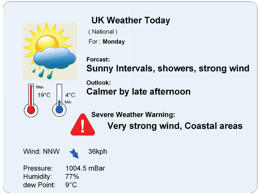
Figure 3 - Sample visualisation of a simple weather report (Figure C.1 of the standard)
Annex D (informative) Recommended translation between WEA and WMO SYNOP tables of observation codes
This annex (6 pages in length) contains a table setting out the links between the SYNOP codes and the codes set out in the document described.
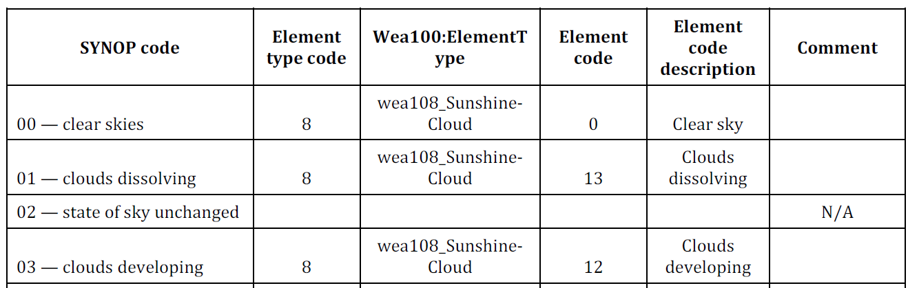
Figure 4 - Excerpt from the SYNOP and WEA interconnection table (Table D.1 of the standard)
Literature
This section (1 page in length) contains references to literature and standards used in the document described.